51. Calderwood within the Almondell and Calderwood Country Park
Calderwood within the Almondell and Calderwood Country Park displays late Ice Age and post Ice Age deposits as well as present day erosional processes. It is an SSSI due to the presence of valley fen and upland mixed ash woodland.

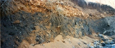
This site is on the Linhouse Water south-east of Livingston. The grey material which forms most of the bank is glacial till. This is formed from material which was picked up, ground down by the ice and then smeared over the landscape beneath the moving ice.
The overlying material is glacio-fluvial deposits. These were originally glacial moraine, which was transported and re-deposited by glacial meltwater rivers as the ice melted. The dynamic and chaotic nature of these processes can be seen by the great variation of particle sizes in this deposit. This indicates that the river suddenly dropped its load: more gradual deposition would have led to the deposits being more graded, with the heavier stones dropping down first and the finest particles being carried much further downstream.
Today this is a site of active erosion, including landslips. Heavy rainfall and snowmelt result in some of the glacio-fluvial deposits being washed down. Water running over the till will remove some of the clay and dislodge stones, some of which can be seen in the river. At times there are actual landslips. Much of the sand at the base of the bank has come from above, with some probably added from farther upstream. During the next high river flow this will be washed away and be deposited further downstream on its intermittent journey to the sea. With falling river levels more sand will be deposited.
Almondell and Calderwood Country Park has good walking paths and parking options. There is nearby geodiversity site located in Almondell and Calderwood Country Park (see site 10) and other site close by along Linhouse Water (site 37).


