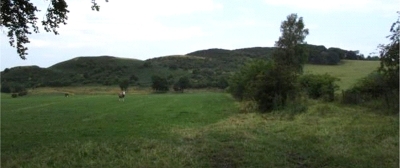
46. Torphichen Hill in the Bathgate Hills
Vast quantities of glacial meltwater overtopped Torphichen Hill when other escape routes were still blocked by ice. A pre-historic site on the southernmost hill is a Scheduled Ancient Monument.

The ridge of Torphichen Hill, paradoxically, displays excellent examples of water cut channels. As the last ice sheet was melting, about 18,000 years ago, the tops of the hills were the first to emerge from the ice. Western escape routes for these vast quantities of water were blocked by ice, so the water drained to the east or north-east. In some cases, like here, the glacial meltwater went over the hills in its path. On Torphichen Hill this water exploited weaknesses along faults in the sill, cutting deep glacial meltwater channels through the ridge. They can be seen as nicks on the skyline. The site of a late Bronze Age-Iron Age hillfort on the southernmost hill is a Scheduled Ancient Monument.
The Hill is east of Torphichen Village, where you can park to visit the site. Nearby geodiversity sites are Cairnpapple Hill (20), Carribber Glen (31), Barbauchlaw & Barbauchlaw Burn Quarries (33) and Witch Craig Wall (39).


