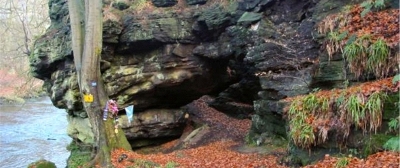
32. Wallace's Arch on the River Avon near Westfield Village
This unusual feature was created by a raging meltwater river at the end of the Ice Age, which was able to cut through this bluff of about 320 million year old sandstone.

Wallace's Arch is formed in a thick layer of sandstone, laid down about 320 million years ago and lies directly underneath the Scottish Lower Coal Measures Formation. The arch was formed at the end of the last glacial period, when meltwater created a huge raging torrent, laden with stones. Unusually, the river was able to erode a tunnel through this bluff, probably because there were more joints in the rock there. Today's river, like many in the Lothians, now occupies only part of its late Ice Age valley.
This cave is said to have been a hiding place for Sir William Wallace after the battle of Falkirk in 1298, but there is no direct evidence for this.
Wallace's Arch is on the south bank of the River Avon about 2 km north-west of Torphichen. The nearest public parking is at Westfield Village and the site can be reached through a right of way path and footbridge along the River Avon Heritage Trail. Nearby geodiversity sites are Carribber Glen (31) and Torphichen Hill (46).


