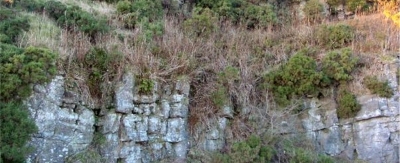
27. Rifle Range Quarries, Bathgate Hills
Here, the limestones deposited in shallow and turbulent water have resulted in the remains of marine creatures being broken up. Nevertheless, sufficient fossils can be identified to demonstrate the abundance of crinoids, corals and brachiopods.

The Rifle Range Quarries expose layers of limestone from the middle part of the Carboniferous Period, the same limestone as seen at the nearby Petershill Quarries (Site 26). However, the limestone here was deposited closer to the shore, so deposition was in shallower and more turbulent water. As a consequence the hard calcareous remains of the abundant marine creatures were almost invariably shattered on death and deposition. This has resulted in two different types of rock. In one, very small pieces of these remains were mixed with fine-grained sediments. In other cases, the broken remains were larger and more abundant, so fossils can often be easily identified. These demonstrate that crinoids and corals were common. Also, the aptly named Gigantoproductus thrived here - this was a large brachiopod, a common shell in Carboniferous seas.
The Rifle Range Quarries are located near Bathgate, approximately a kilometre north-east of Petershill Quarries and south-west of The Knock (see sites 26 and 38). The easiest parking can be found in the roadside quarry at The Knock or at Petershill Wildlife Reserve. Other nearby geodiversity sites are Five Sisters Shale Bings (5) and Skolie Burn (25).


