11. Upper Uphall
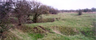
The underlying geology is responsible for various surface features in Upper Uphall. These include surface collapse from shallow underground workings of oil shale; a small oil-shale bing and remains of a dismantled mineral railway.

The village of Uphall has a long mining history. This site provides excellent examples of landforms resulting from mining and quarrying and their associated features. Shallow underground oil shale workings, known as "stoop and room", have resulted in the collapse of the ground where it was not supported by the pillars of shale left to hold up the roof. There is also a small oil-shale bing and the remains of an old dismantled mineral railway nearby. The ground is now used for cattle grazing.
Uphall, located to the north-east of Livingston and the site can be reached from the Uphall Community Woodland. On-road parking is available in Uphall near St Andrew's Drive. Nearby sites are Greendykes Bing (7) and Binny Craig (42).


