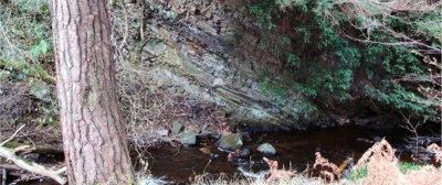
9. Murieston Water by Calderwood Country Park
Fault-related structures in thin beds of siltstone are exposed alongside the Murieston Water near Calderwood Country Park.

Murieston Water is a river that has its source near Cobbinshaw Reservoir, south of West Calder, and its flows northeast through Almondell and Calderwood Country Park. South of Mid Calder, near to where the Murieston Water joins the Linhouse Water, there is an exposure of thin beds of siltstone in the river bank. These sedimentary rocks are close to the Calder Fault, one of several faults that run approximately west-east across West Lothian. These rocks have moved downwards relative to the rocks to the south of the fault, and show evidence of deformation caused by the fault movement.
Murieston Water is part of Calderwood Site of Specific Scientific Interest (SSSI) where valley fen and upland oak woodland are protected. Pleasant woodland extends along much of the middle and lower reaches of the river, with the wooded Murieston Trail extending from Campbridge Park along the Murieston Greenway near Livingston South Rail Station towards Calder Wood. The area provides a range of excellent walking trails. Nearby Calderwood site within the Almondell and Calderwood Country Park (51) and two geodiversity sites in Linhouse Water (37 and 45).


